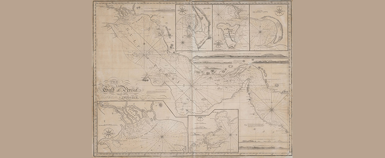
This is one of the most important charts in Qatar’s cartographic history. It marks the re-emergence of the Qatar peninsula on commercially made maps after a 227-year absence. The Qatar place names of Zubarah (“Zebarra”), Khor Hassan (“Koor Hufsan”) and Ras Rakan (“Ras Reccan”) can be found on the chart.
Qatar has been a known place since the time of Ptolemy, nearly 2,000 years ago, and the presence of the peninsula was represented in maps from 1548 to 1596. However, the Linschoten chart of 1596 marked the last appearance of Qatar until this chart was published in 1813.
Why did Qatar mysteriously disappear from maps for more than two centuries? Christopher Alario, the Library’s information services librarian for historical maps, theorizes that the shallow waters kept large Dutch and British ships far into the Gulf. At that distance, they wouldn’t have been able to see Qatar.
The Portuguese, however, who created the earlier maps, had used smaller boats and thus could get close enough to accurately map the coast. Maps from the 1500s appear to come from Portuguese sources, whereas later maps are derived from British and Dutch explorations—and lack Qatar.
At the time this chart was published in London, the famous Brucks Expedition, which was the first to fully survey the Gulf and Qatar, was still ongoing.
Take a cartographic trip through the past in Jerry Brotton’s A History of the World in 12 Maps, available as an ebook through OverDrive. The Men Who Mapped the World: The Treasures of Cartography, by Beau Riffenburgh, offers a richly illustrated look at the importance of maps and their evolution.
Of course, today we have a plethora of reliable maps at our disposal. National Geographic’s Atlas of the Middle East takes a deep dive into the region, its people and its history through dozens of full-color maps.
Add new comment